Friday 29 June 2012

Assam Tea Gardens


The tea plant is grown in the lowlands of Assam, unlike Darjeelings and Nilgiris, which are grown in the highlands. The Assam tea bush grows in a lowland region, in the valley of the Brahmaputra River, an area of clay soil rich in nutrients of the floodplain. The climate varies between a cool, arid winter and a hot, humid rainy season—conditions ideal for it. Because of its lengthy growing season and generous rainfall, Assam is one of the most prolific tea-producing regions in the world. Each year, the tea estates of Assam collectively yield approximately 1.5 million pounds (680,400 kg) of tea.


Assam tea is generally harvested twice, in a “first flush” and a “second flush.” The first flush is picked during late March. The second flush, harvested later, is the more prized “tippy tea,” named thus for the gold tips that appear on the leaves. This second flush, tippy tea, is sweeter and more full-bodied and is generally considered superior to the first flush tea. The leaves of the Assam tea bush are dark green and glossy and fairly wide compared to those of the Chinese tea plant. The bush produces delicate white blossoms.

Thursday 28 June 2012

Explore Cherrapunjee, Meghalya

cherrapunjee
Cherrapunjee being the wettest land on the earth, because of rains throughout the year has numerous waterfalls falling from great heights. Nohkalikai Falls is one of them, falling from the height of 1100 feet or 335 m. This is the tallest waterfall of India. As the collected rainwater on the summit of a small plateau give birth to this waterfall the intensity of the fall decreases during dry seasons that is in between December and February. The waterfall falls enthusiastically from this great height to the hard rocks to form a fantastic green colored pool, which is really an eye -catcher. This great fall lead to the formation of a big cavity behind the fall.


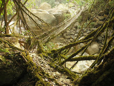
root bridge
A variety of Indian rubber tree growing along the banks of the rivers or the streams of this hilly region scientifically named Ficus elastica, give out prop roots from the trunks of the trees. These prop roots are well known for their strength to carry heavy weights. These trees can grow easily on huge boulders besides the river or stream and can send their secondary roots to the riverbed for absorption of water and mineral, so the soil erosion caused by the fast flowing rivers and the streams do not affect them.

To form the bridge the locals direct the roots in the desired direction, by passing the tender roots through hollow beetle nut tree trunks. When the roots reach the desired destination, they are made to root themselves in the soil. These bridges have floor made up of more than two roots and it has two protective railings made up of these roots only. Sometimes for extra support, the secondary roots from the trees are brought down to join the middle of the bridge. To fill the gaps in the floor of the bridge, stones are used, which get fixed in the floor of the root bridge after some time. Sometimes the hanging roots of the trees growing on opposite banks of the river or in the middle of the river are made to intertwine each other and join the banks of the river or the streams.

These bridges have great strength that they can carry even the load of 50 or more people at a time and as the roots of these bridges are living their strength grow with the passing years.

Tourists can even hop around on the Double Decker Root Bridge , which is made of two bridges piled one above the other. This particular bridge in located in Nongriat village of cherrapunji and named as Umshiang Double Decker Bridge , as it is built over the stream named Umshiang . This bridge is considered to be very special one as it is the unique one in the entire world.

Around 10 to 15 years are required by these bridges to become operational and they have a life span of around 500 to 600 years. This is an excellent example of bioengineering.

Explore cherrapunji @ www.hoparoundindia.com

Wednesday 27 June 2012

Shakti Peethas (Chamundeshwari Devi)

Chamundi Hills is 13 kms from Mysore by road or by climbing up by the 1,000 steps laid out by the Maharaja in the 17th Century. It is a well-known 335 meters high landmark atop which is the Chamundeswari temple that dates back to the 11th century. Goddess Chamundeswari is an incarnation of Goddess Parvathi who took this form to destroy the demon king Mahishasura. Nearby to the temple, there is a statue of Mahishasura, who was a demon killed by the goddess Chamundeswari.


You will also find the monolith Nandi, the bull, which is located near the temple. Form the top you can take a beautiful view of the city of Mysore.

You can take the "Darshan" of "Jwalamukhi Amma" Temple nearby, which is approximately 3 km from Chamundeswari temple. And Sri Ganapathi Sachidananda Ashram, which is situated in the foothills of Chamundi Hills, is worth visiting.

A View from Chamundi Hill

Monday 25 June 2012

A Hill Station with Paragliding

Floating clouds, undulated hill-sides, meadows with thousands of wild flowers that appear landscaped; well-laid walkways; surrounded by other green hills in close proximity and vicinity and towered by humungous snowy Himalayan Mountains at a distance is what the Deolo Hill is all about.  It is a big hit among honeymooners and highly visited by families during the summers when Deolo Hills sports pleasant weather and picturesque environment.

Deolo Hill is a picturesque and a green hill with dense vegetation and wild flowers which grow effortlessly.

Deolo Hill serves a very important function of storing water in its reservoir and supplying drinking water to its own hill settlement as well as to Kalimpong town of West Bengal.


Paragliding at an altitude of 6230 feet above sea level on Deolo Hill is a must-try for an adventure-sports enthusiast.

There are two paragliding flight-routes:

Deolo to Ronaldshay Park in Kalimpong - 30 minutes duration.
Deolo to Relli River - 30 minutes duration.

These flights offer breathtaking aerial views of the Himalayan Mountains, hills, valleys and big rivers.


Check for more attractions of Deolo @ www.hoparoundindia.com


Wednesday 20 June 2012

Niagara Falls In India

Chitrakoot Falls are located 48kms west of Jagdalpur (a small city) in the state of Chhattisgarh. This waterfall is considered the Niagara Falls of India and is the broadest waterfall in the nation. The chitrakoot is also a religious Hindu Pilgrimage center. Thousands of pilgrims come here for Hari darshan and pay their homage to the God Hari. Who ever comes to Chitrakoot makes sure to visit Chitrakoot Waterfall at least once.


People can spend hours just sitting here and enjoying the scenic beauty of the place. The loud noise during monsoon is breathtaking. During the rains, this waterfall widens upto 150 meters. During the rainy seasons, people don't visit this waterfall, owing to its extreme form. But once, the winter season arrives, the water becomes lighter, and the atmosphere here is worth seeing.

he water color changes from season to season. In monsoon because of silt it turns a little brown in shade whereas in summer it’s white and clear. The shape of the waterfall is like a horse-shoe. Tourists can stay here at the government owned resorts or at the camps near the banks of river. There are also various resorts and lodges available on the Jagdalpur-Chitrakoot Road which are nice and comfortable for the visitors to stay.

Best time to visit:


The first time visitors are sure to fall in love with this place and they just can’t have enough in just one visit. If you want to enjoy the wildness of the waterfall then July to the month of October would be the best time, the waterfalls of Chitrakoot attain its best phase and widens up to 150 mtr. But if you want to enjoy the calm white waterfall then best time to visit is during the winters which start from Oct to Feb.

Tuesday 19 June 2012

Wettest Place on Earth


Mawsynram is reportedly wettest place on earth, with the highest average annual rainfall. Listed in Guinness book of world records, as per Guinness book rainfall recorded 26,000 millimeters of rainfall in 1985 and it is reported the wettest place on earth.

This wettest place located at 16KM from west of cherrapunjee, on Khasi Hills in Meghalaya, India. The word Maw, meaning stone and thus might refer to certain megaliths in surroundings. These Hills are rich with such megaliths - Khasi monoliths erected fairly recently to commemorate important events and people.

This place features a subtropical highland climate with an extraordinarily rainy and lengthy monsoonal season, when checked with Koppen climate classification. And this place 12 m of rain in an average year, and a majority of it falls during the monsoon months.

Sunset View point in Mawsynram
Three reasons can be cited for high rainfall at Mawsynram:

1. The warm moist winds of the northward-moving air from the Bay of Bengal during the monsoon, which cover an extensive area but are forced to converge into the narrower zone over the Khasi Hills, thus concentrating their moisture.

2. The alignment of the Khasi Hills (east to west) places them directly in the path of the airflow from the Bay of Bengal, producing a significant uplift (plus cooling, further condensation and thus more rain).

3. Finally, uplift over the Khasi Hills is virtually continuous in the monsoon period because the lifted air is 
constantly being pulled up by vigorous winds in the upper atmosphere; hence the rainfall is more or less continuous.


Mawsynram, one of the well known spots of Meghalaya, and is frequented by nature lovers enjoying a walk by its steep and down sliding slopes, breathing in the fresh air, experience the clear blue sky, the wind that brushes their face, catching glimpses of the mountain birds and the nearly deafening sound of the roaring waterfalls. The orchids that bloom on the low lands, the thrilling adventure in the unexplored caves that are pathways to many rivers are experiences that remain forever acting as a balm for the city bred travelers looking for solace in nature’s soothing memories.


Yet another attraction near this wettest place is a cave called the Mawjymbuin Cave which is one of the well known caves in Meghalaya. This cave, due to years of weathering and due to dripping of mineralized solutions and deposition of calcium carbonate, it has thus given rise to some magnificent stalagmites. An extraordinary rock formed by geological means called Symper Rock is located close to the Weiloi Village, at a distance of one and half kilometers from the Ranikor-Balat -Mawsynram-Shillong Highway. This place is famous for the gigantic formation of stalagmite, which resembles the shape of a 'Shivalinga'. This formation is housed in a cave, whose local name is Mawjymbuin.

Wednesday 13 June 2012

One of the Two Dams in india, Tallest Dam's in the World

The Tehri Dam is a multi-purpose rock and earth-fill embankment dam on the Bhagirathi River near Tehri in Uttarakhand, India. It is the primary dam of the Tehri Hydro Development Corporation Ltd. and the Tehri hydroelectric complex. The dam is a 260 metres (850 ft) high rock and earth-fill embankment dam. Its length is 575 metres (1,886 ft), crest width 20 metres (66 ft), and base width 1,128 metres (3,701 ft).


A preliminary investigation for the Tehri Dam Project was completed in 1961 and its design was completed in 1972 with a 600 MW capacity power plant based on the study. Construction began in 1978 after feasibility studies but was delayed due to financial, environmental and social impacts. In 1986, technical and financial assistance was provided by the USSR but this was interrupted years later with political instability. India was forced to take control of the project and at first it was placed under the direction of the Irrigation Department of Uttar Pradesh. However, in 1988 the Tehri Hydro Development Corporation was formed to manage the dam and 75% of the funding would be provide by the federal government, 25% by the state. Uttar Pradesh would finance the entire irrigation portion of the project. In 1990, the project was reconsidered and the design changed to its current multi-purpose.[1] Construction of the Tehri Dam was complete in 2006 while the second part of the project, the Koteshwar Dam, is nearly complete with two out of four generators operational. The other two are expected to be commissioned in March 2012 while the pumped storage power planned is slated for commissioning in February 2016.


Monday 11 June 2012

One of the tallest dam in World

Bhakra Dam is a concrete gravity dam across the Sutlej River, and is near the border between Punjab and Himachal Pradesh in northern India. The dam, located at a gorge near the (now submerged) upstream Bhakra village in Bilaspur district of Himachal Pradesh, is Asia's second highest at 225.55 m (740 ft) high next to the 261m Tehri Dam.
Bhakra Dam is a concrete gravity dam across the Sutlej River, and is near the border between Punjab and Himachal Pradesh in northern India.

The dam, located at a gorge near the (now submerged) upstream Bhakra village in Bilaspur district of Himachal Pradesh, is Asia's second highest at 225.55 m (740 ft) high next to the 261m Tehri Dam also in India. The length of the dam (measured from the road above it) is 518.25 m; it is 9.1 m broad. Its reservoir, known as the "Gobind Sagar", stores up to 9.34 billion cubic meters of water, enough to drain the whole of Chandigarh, parts of Haryana, Punjab and Delhi. The 90 km long reservoir created by the Bhakra Dam is spread over an area of 168.35 km2. In terms of storage of water, it withholds the second largest reservoir in India, the first being Indira Sagar dam in Madhya Pradesh with capacity of 12.22 billion cu m.

Thursday 7 June 2012

A Nice Place for Picnic


Also known as the Sumendu Lake , the Mirik Lake is located in the heart of Mirik town at 26.8902, 88.1824 in Darjeeling District.


A pathway circles the whole lake which is 3.5 kilometres. Tall pine forest trees tower over the Lake from almost all sides. An 80-foot long foot-over bridge connects one side of the Lake to the other side and makes the experience of walking across the Lake simple enchanting. And the sight that truly makes this whole trip to Mirik up in the hills worthwhile is when the clouds kiss the Lake and bounce off causing a rippling effect as they drift over Mirik. It s just awesome!


Boating and fishing are offered by the Darjeeling Gorkha Hill Council Enterprises at this Lake. Many horses are available around the Lake for a short trot along the periphery.

Picnics around this picturesque Lake is another great way of chilling out next to the Lake with a book, music, or noisy kids and family.

Mirik Lake is guaranteed to make you click it. So must keep camera handy.

Plan Your Picnic @ www.hoparoundindia.com

Wednesday 6 June 2012

A Picturesque Hill Station


Manali is a city in the Kullu Valley of the Kullu district in Himachal Pradesh. Its geographical coordinates are 32.2396 degrees North, 77.1887 degrees East and is located at an altitude of 1,926 meters above sea level. Located in the Himalayan valleys, the area is mainly irrigated by the Beas River and the Sutlej River.


Kullu District shares its boundaries with Spiti and Lahul on North East, Kangra on North West, Mandi on South West and Shimla and Kinnaur on South East.

Manali derived its name from Manavalaya i.e. the abode of Manu. As per the mythological tale Manu was the only survivor of the Mahajal Pralay (meaning the great flood) in the ancient history of civilization. It was Manu who was believed to be the father of the human race.


Manali is nested in the Kullu district of Himachal Pradesh. It is about 40 km from the district headquarters Kullu. Manali is the enchanting origin point where trade was commenced in the ancient past. The route crossed Rohtang and Baralacha passes and goes via Lahul and Ladakh to Kashmir extending upto Spiti.

Manali is a mesmerizing romantic paradise and a very popular honeymoon destination. Tourists from all over the country including overseas countries love to spend the summer in Manali. The winters are ideal for a cozy holiday and for snow lovers. Manali is an amazing destination for adventure sports where one can enjoy the sport of your choice. The Tourism Department has also very liberally encouraged the sports all over the state and has created extremely comfortable and helpful facilities for sports lovers. The hills and valleys are so fascinating that one wishes to stay back here forever away from all the stress, noise and pollution that haunt city life.

Have a trip to Hill Stations @ www.hoparoundindia.com

All gods at one place - Surendrapuri Yadagirigutta


One can have the Darshan of all the gods in one place, Whether it’s the vanavasam of Lord Rama or the churning of the Ksheera Sagaram (Milky Ocean), the newly opened mythological museum ‘Kunda Satyanarayana Kala Dhamam’ presents Indian mythology to devotees, especially youngsters, in a simplified manner, it was established to create awareness of Indian mythology. this awareness centre inaugurated on 8th Feb 2009.

Panoramic View

Around  60km drive away from the hyderabad city, this museum at Surendrapuri near Yadagirigutta has given a much opportunity to all devotees to get familiar with fascinating events of Ramayana, the Mahabharata, the Bhagavata and other Puranas. All the important events are carved out in the form of eye-catching sculptures employing ultra-modern artistic designs and techniques. That’s not all, this extensive 18-acre set up also has famous replicas of all the important temples and gods such as Kaashi Viswanath, Kolkata Kali, Madhurai Meenakshi, Tirumala Balaji, Shirdi Saibaba, Palani Kumara Swami and Ayodhya Rama.

Check out more city guides @ www.hoparoundindia.com

Tuesday 5 June 2012

A journey starts with hoparoundindia leads to a perfect journey in your lives

Hop Around India - A Journey not a destination...


When Big Becomes BIGGER- Presenting Hop Around India…


How many times have we seen a germ of an idea turning into a great one and a great idea turning into a brand? Well, this seems to be a dejavu for us which was thought about in March 2008 and turned out to be a single…oh no!, a few great ideas comprising of Baatasaari.com, Prayaanika.com, Payanigal.com respectively - to empower the traveler to exclusively visit and explore the state of Andhra Pradesh, Karnataka, Tamil Nadu, India.
The great idea has led into a brand and not just a brand but a big brand which promises to become bigger and bigger as time passes by. Launching HopAroundIndia.com on a bigger platter to travelers around means re- architected and re-exploring India as it should be.
We are all but delighted to unveil our new brand logo, and HopAroundIndia.com website with a completely new look, feel and features emphasizing more on customized travel information on India. The website is all set to focus on providing a virtual tour of India to all its visitors, and touted to make traveling in India more affordable and accessible at the click of a mouse.
Why the change? Well, as they say- except ‘change’ everything is permanent, so we thought of a change and a change for good. As travel experts we thought people world over should know, learn and explore India the way it should be. Spoon-feed travelers, highlight unexplored regions of India, and make traveling a commodity not just for the rich and the famous…and much more. We will be directing our efforts to research develop and display useful and quality travel ideas and information to the travel community within and outside India especially with the local people who will be the back bone of this.
So get cracking and we'll always welcome your comments, feedback, and criticisms, either here or at
info@hoparoundindia.com.


Courtesy :- www.Hoparoundindia.com

Monday 4 June 2012

Wayanad Wildlife


Wayanad Wildlife Sanctuary is an animal sanctuary in Wayanad spread over 344 sq. km, and is bounded by protected area network of Nagarhole and Bandipur of Karnataka in the northeast, and Mudumalai of Tamil Nadu on the southeast.It is a part of the Wayanad plateau and the vegetation mainly consists of the deciduous teak forests and semi-evergreen trees.


This second largest wildlife sanctuary is also called as "Muthanga Wildlife Sanctuary". There are many mountain peaks inside the sanctuary, the most prominent one being the "Karottimala". This peak is situated at a height of around 3,800 feet above the main sea level. The other important mountain peaks inside the sanctuary have altitudes ranging between 2,100 feet and 2,600 feet.
The wildlife sanctuary comes under Protect Elephant mission and thus houses a number of elephants. The Elephant rides arranged by the Forest Department, is an exciting and memorable experience.
It also houses animals such as Slender Loris, Indian Bison, elephant, deer, panthers, jungle cats, civet cats, monkeys, wild dogs, bisons, deer, bears, monitor lizards and a variety of snakes and tiger. There are more than 216 species of birds in the sanctuary including Peacocks, babblers, cuckoos, owls, jungle fowl, pariah kite, crested honey buzzard, paradise flycatcher, woodpeckers and Peafowl.


Different varieties of fish, such as Malabar catopra, korhi barb, Wayanad barb, snake heads, giant danio and Wayanad mystus, are found in the streams and rivers flowing through the sanctuary.
The forest vegetation consists of maruthi, karimaruthi, rosewood, venteak, vengal, chadachi, mazhukanjiram, bamboos, veteria indica., lagerstroemia, lanceolata, termianalia paniculata etc.
It is the second largest wildlife sanctuary in Kerala amidst lush green forests and is under consideration by the UNESCO World Heritage Committee for its selection as a World Heritage Site. The sanctuary is divided into two separate parts known as the Upper Wayanad Wildlife Sanctuary in the north and Lower Wayanad Wildlife Sanctuary in the south. The area in between the two parts was originally a forest region, and is now occupied majorly by plantations. The Forest Department aims at the conservation of the environment with due consideration for the general lifestyle of the tribal and others who live in and around the forest region.
Jeep Safaris are arranged by the Forest Department for visitors to enjoy the views of the Sanctuary.

For more information on Sulthan Bathery @ www.hoparoundindia.com

Saturday 2 June 2012

Ads

Friday 1 June 2012

HOP AROUND INDIA'S JUNE NEWSLETTER


Sindhu Darshan Festival –June 1 to June 3

Sindhu Darshan Festival is celebrated in Ladakh in the month of June on Guru Poornima. It is a symbol of multi dimensional cultural identity, communal harmony and peaceful co-existence to the Sindhu’s in India. River Sindhu is considered to be Religious place as it originates from the holy Lake Mansarovar and people all across the country worship the place to make offering of the holy river. Sindhu Darshan Festival includes traditional ceremonies involving Buddhist prayers by senior Lamas, which begins the festival. A series of cultural programs and performances by artists from various parts of the country follows.

Father's day – June 17
Your biggest hero deserves your biggest thanks.    

Dad :- "Sons first hero and Daughters first love"

This celebration began in Spokane, Washington. A woman by the name of Sonora Smart Dodd thought of the idea for Father's Day while listening to a Mother's Day in 1909. Sonora wanted her father to know how special he was to her. It was her father that made all the parental sacrifices and was, in the eyes of his daughter, a courageous, selfless, and loving man. Sonora's father was born in June, so she chose to hold the first Father's Day celebration in Spokane, Washington on the 19th of June 1910. In 1924 President Calvin Coolidge proclaimed the third Sunday in June as Father's Day.

Father's Day is a celebration honoring fathers to recognize the contribution that fathers make to the lives of their children. It is celebrated limitedly in India compare to UK and US. Many countries observe this day on the third Sunday in June. The idea behind celebrating this day is to inspire children to pay due respect to their father and care them. It is considered to be celebrated for the person who help you out when you need him, to make you feel secure, to take care of all pressures in your life. He was there for your first step, your first fall and your future needs. Children pay respect to their fathers as well as present them a best gift. He will be considered as a role model. Red to be worn for a living father and White if the father has died.

Jagannath Rath Yatra – June 21st

The Ratha Yatra or Ratha Jatra is celebrated in the town of Puri in the state of Orissa. This festival is celebrated towards Lord Jagannath. It is the most famous and spectacular festival which attracts huge Travelers from all over India and also from out Countries. This festival takes place in Asadha Sukla Dwitiya when the image of Lord Jagannath, Balabhadra, Devi Subhadra and Sudarashan are taken in three separate chariots to Gundicha Mandir over 14 to 10 Miters it is pulled by devotees rather than horses. The ropes of this chariot are considered to be the threads of redemption. Ratha Yatra festival is celebrated for around eight to ten days. The initial days of the Yatra is observed as a public holiday in Orissa. People decorate their houses and shops with color full Flowers, Lights and Rangolies. They prepare traditional desserts and sweets especially for this occasion. It is also customary to hold back from non-vegetarian food during these days.

Hemis Festival – June 29 to June 30

Hemis Festival is celebrated in the month of June in Ladakh on the birth anniversary of Guru Padmasambhava. It is celebrated in the divine Hemis Gompa, the founder of Tantric Buddhism in Tibet. Lamas from different corner of the country visit the place and engage themselves in performing mask dances and sacred plays. They use drums, cymbals and long horns for the music.

Source www.hoparoundindia.com